Thursday, September 26, 2013

PART XVI: DOLOMITI (9/8 - 9/12)


View Europe Travels in a larger map. Don't forget to click on pictures to make them larger.

Our drive into the Dolomites took us through some amazing scenery including the Valle di Lagi (Valley of Lakes).

Our first stop was at this amazing new natural history museum in Trento. Here is a photo of us all walking out of the main entrance to give you an idea of the crazy architecture of the place. They also had a biodome containing a Tanzanian jungle environment, hundreds of taxidermied animals and dinosaurs, and tons of information about physics, geology, biology, chemistry, history, mountaineering, and the Dolomites.

We drove on some pretty precarious mountain roads in the Dolomites but I can't imagine being a bus driver here.

The view from just outside the front door of our hotel the morning after we arrived.

The view from our hotel.

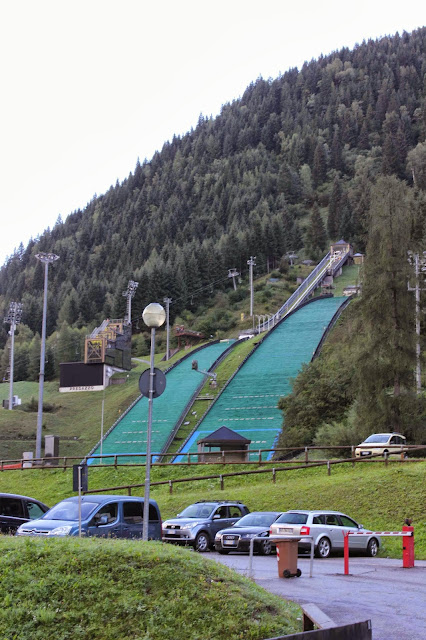
The Olympic ski jump training center was right at the base of the gondola we rode in the morning of our first day in the field. You might be able to see the person flying through the air just after leaving the ramp in this picture.


We took a second chairlift to get nearer to the top of the Latemar, a mountain and ski resort. All the poles here are snow makers and hold up nets to prevent people from skiing off cliffs and into the woods.

Hannah takes the same exact picture.

This is about where we stopped to...

...sketch a face of the mountain and learn about carbonate platforms formed about 240 million years ago.

The cows really wanted to ride the chairlift back down to their farm but no one bought them a ticket. Apparently the cows are turned out to graze in the morning after milking and know to return to the barn on their own a sunset.

The gorgeous red color on this hillside is from patches of a low-growing scrubby plant that replaces the grass in some places.

Adelweiss!

I made a little cairn balanced on the edge of one of the outcrops.

The last of the figs harvested at Coldigioco before we left. They make a great snack.

We made an inukshuk by the road while we waited for an hours or so for a road crew to repair a road destroyed by a landslide the next morning.

That little farm over there had a bunch of unruly pigs that the farmer had to chase around the hill to get them inside. He also brought his herd of cows back to the barn while we were at the outcrop on the left edge of the picture and they all walked right by us. He looked like a real traditional herding farmer with a sheep dog, walking stick, and Robin-Hood-looking hat that is native to the area.

We found a cave!

The view from the hotel the next morning when the clouds had left the peaks completely. It snowed in the mountains!

The reservoir just below the Marmalada glacier that we went to in the morning of the third day.

I rode the chairlift up with Sandro. It was less of a chair and more of a two-person basket however.

We saw a few people walking up this trail on our way back down. It must have taken them at least two hours to get to the top. We also saw fresh tracks in the snow from someone who had climbed up the glacier earlier that morning and...

...skied down!

The Marmalada glacier is the first glacier I have ever seen in person.

During WWI when the glacier was about a kilometer farther downslope, the Austria-Hungarians build a city housing about 2,000 troops and tons of supplies in the glacier. Here is a little bunker outpost used to keep a lookout for the encampment. You can see all the way to Austria in the very left edge of the picture. There was a major front of the fighting in this very valley and the Italians built a similar city into the rocks of the mountains on the other side of the valley. I was amazed to learn that each of Sandro's grandfathers (one Italian, one Croatian) each fought on opposing sides during the war. Apparently each day when the shooting was over the soldiers would leave the trenches and meet up with soldiers from the opposing side of the war at the local bar to play cards and drink. The Dolomites seemed less Italian and more a part of Alpine culture as seems to happen in many of the countries that share the Alps.

The whole gang. I tried getting in there but apparently didn't get the auto-timer to work. Colin got a better picture with me in it as well.

Travis inspects a little frozen puddle and a tiny patch of grass that grows even all the way up here at the glacier.

As the glacier melted, artifacts of the war dropped out and were collected by a man we met who has now put is collection on public display.

In the afternoon we drove up to Passo di Salle and saw all these parasailers flying around.

We even saw them taking off!

A little bit of stream bed geology anyone?

A bar up on the mountain had fancy fowl including these peacocks.

And this crazy chicken.

The parasailers fly by the bar.

On our drive out of the Dolomites we stopped at the Vajont Dam where on October 9th, 1963 a huge landslide fell from the hills above the reservoir and created an enormous tsunami that completely destroyed a number of villages downstream killing 1,900 to 2,500 people. The prayer flags here have the names of the hundreds of children that were killed that day.

The dam remains but no longer functions as a hydropower generating station like it did for the four years between its completion and the landslide. The water here is flowing through underground conduits from the reservoir that, although diminished, still fills the valley above the dam. We walked across the top of the dam from which I got this picture looking into the gorge below the dam.

The holes in the cliff side are where the road we took to get to the dam pops out of the cliff every once in a while. You can see one of the cities that has been rebuilt since the landslide in the valley beyond as well.

We walked through that nice covered walkway more than 200 meters above the river bed below.

Wednesday, September 25, 2013

PART XV: MONTE SAN VICINO (9/6)

Colin, Alex, and I decided to use a weekend day to hike up Monte San Vicino, the largest mountain nearby Coldigioco. A 2 hour walk got us to the top and we took a longer, gentler route on the return to home.
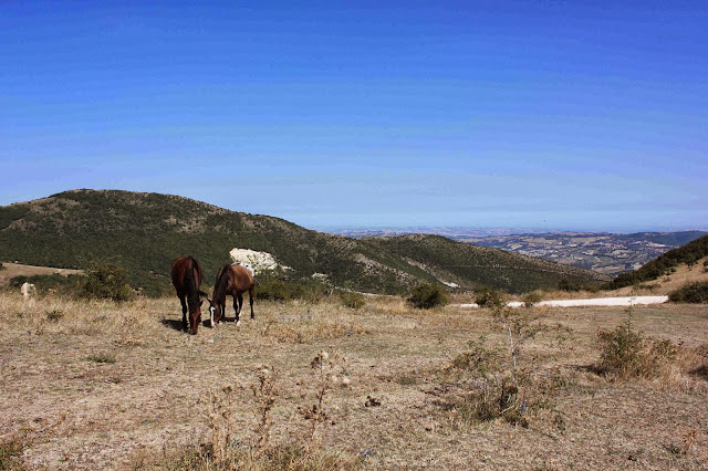
A harras of horses was turned loose on the shoulder of the mountain so hung out with them for a while.

Climbing in the sun was incredibly hot but the various environments we hiked through were gorgeous: fields, rocks, forests, villages.

Looking west on the summit one can see the weather station and cross that were at the top of the mountain. Almost every mountain top I saw in Europe had a cross on it of some size. This one was about 30 feet tall, which made it taller than most.

Look south.

Looking north.

Looking northwest...oh look who it is!

The sun over the mountain as we walked home.

Tuesday, September 24, 2013

Big History


Check out ChronoZoom, the visual tool used for conceptualizing and compiling a Big History of the universe. Walter Alvarez, a geologist and friend of Sandro's, gave a talk today about Big History and how it can be a mindset of curiosity and answer seeking that can really enrich the way we look at the world. Walter is one of the founders of this notion of Big History as well as its international association, the IBHA. Also check out the Big History Project David Christian talked about at the end of the video.

Devon showed me these drawings that when viewed from a particular point look three dimensional.

Monday, September 23, 2013

PART XIV: TOSCANA (8/30 - 9/3)


View Europe Travels in a larger map and don't forget to click on pictures to make them larger.

This is a view of the cooling towers of the geothermal power plant we visited. This plant injects water at up to three kilometers into the ground and the resulting steam is used to power turbines. It is built on the site and using similar technologies to that of the very first geothermal power plant built in Italy during the early twentieth century.

We saw a demonstration of purging of one of the old wells, which is now only used for demonstration purposes. This steam cloud is the result of only four atmospheres of pressure applied to water injected only 700 meters into the earth, a fraction of the the pressure, depth, and resulting temperature of the wells drilled today.

A marble company is pictured in front of the mountains that supply marble to much of Italy and the world for decorative uses.

This is the mine that supplied the Sculptural Carrara marble that Michelangelo used to sculpt his David and many of his other works. Taken from the overlook at Mt. Pizza with the Tyrrhenian Sea (Western Coast of Italy) in the distance and Pisa in the top left corner of the picture about 60 kilometers south along the coast.

The whole gang at the overlook on Mt. Pizza overlooking the marble quarry.

Fall starts to show its colors on the hillsides of Tuscany.

The ethereal hills of the late afternoon looking from our chalet balcony at the monastery where we stayed.

The chalet all us students stayed in at the monastery.

The sunset from the chalet balcony.

We return to the main building of what used to be a monastery where we stayed and ate our breakfasts and dinners while in Tuscany. Although it is no longer functioning as a monastery, there was a small chapel and a pair of priests staying at the monastery while we were there, one of who was quite good at ping pong and who nearly beat Alex in a best of three game tournament.

Alex and Robbie play Colin and Alyssa at the foosball table (biliardino), which seem to be ubiquitous across Italy for entertaining youth and the population generally.

The Alpi-Apuane peaks from the field above the monastery (Alpi refers to the Alpine look of this short sub-range of the Apennines and Apuane refers to the mountains actually being part of the Apennines).

A raw milk vending machine located at a local gas station. Because ya' know...that's a thing.

We head into an unmarked cave next to the road to explore some karst geology, or the formations resulting when rainwater interacts with limestone formations.

Sandro looking serious as he talks about a stalactite that used to be joined to a stalagmite here and river deposits in the cave from a time when a river actually ran into this cave.

Alyssa and Alex looking for bats.

Praying mantises were everywhere. One time when we told Sandro he had a praying mantis on his hat all he said was, "I'm not Catholic."

Cows near a summit.

All the summits in Italy have crosses to mark the most visible point near the summit.

Jordan inspects his kingdom.

Alex checks out a reservoir near one of our roadside outcrops.

A stream bed afforded us a look at an incredible variety of colored rocks from a number of formations including these purple, green, and grey limestone pebbles all from the Scaglia Toscano formation, which I used to make a cairn.

It is totally normal to see ruined and abandoned buildings throughout Italy. Here is one leading up to the marble quarries.

Sandro stands in the bottom of a marble quarry that we were given permission to check out and explore when it was closed over the weekend. It was much bigger than can even be seen here and cranes hung over it and machinery was scattered everywhere. This particular quarry does a lot of business with the Vatican and the Catholic Church.

A little house near the bottom of the valley the marble quarry was in.

Travis, my roommate, peaks his head out of the little stone house.

We had our last Italian class in this mountaintop glacial terrace.

Another beautiful reservoir in the mountains.

We did some bouldering as well as geology in this stream bed in a very deep gorge surrounded by volcanic pillow basalts.

Alyssa watches Alex jump down from a boulder to make sure he doesn't break anything.

A cairn I made in a different streambed.

Sandro traces the profile of pillow basalts cut by this perfectly smooth road cut as we leave the Tuscan Apennines and head home.